Fire, Ice and Trolls, Part 1

At the entrance to the Blue Lagoon.

Everything I tell you is true.  This is the way it happened.  So began one of many sagas we would hear in Iceland, this one coming from Christian, the owner of a small café called Café Bryggjan.  Bryggjan means “pier” in Icelandic, and this fisherman’s café is in a small seaside town called Grindavik at the water’s edge of a harbor.  After landing at the main Iceland airport in Keflavik at around 4:45 AM, we got through customs very quickly, picked up our bags, and got our rental car.  I rented from Budget, yes, the same as in the USA.  Our car was a Skoda, made in the Czech Republic, very comfortable, well-built, full-time four-wheel drive (important in Iceland), and large enough for four with our suitcases.  It happened to be a diesel automatic.  We then drove off to find our way to Grindavik and the Bryggjan Café.

You may wonder, as I did, why many place names in Iceland end in “vik”.  As it happens, “vik” means “bay, inlet or cove”  in Old Norse.  So, Reykjavik is Reykja Bay, and so on.

When we arrived in Grindavik and found our way to the restaurant, we were impressed by the plainness of the buildings, and the location of the restaurant, practically at the edge of a large harbor.  We, the four in my group, and the rest of our group, another five traveling with us in another car, met up at the café.  They had rented the very same Skoda we had.  Popular car, that Skoda, in Iceland.  The café was still closed, as it was only 6:30, and it opened at 7:00.  There was another couple waiting for the place to open, a mother and daughter traveling together.  We chatted a bit outside, checked the hours on-line to be sure we were not mistaken about it opening on Sunday, and milled about for a while.  It was cold, slightly raining and windy, so before long, our group made their way back to the cars to sit out of the weather.  Then, a slightly portly looking gentleman dressed in clothes more appropriate for a warm spring day, headed to the back door and opened up the restaurant.  He was very friendly and welcomed us all in.  He explained there were two breakfast options, the light plate, and the full fisherman’s breakfast, which included smoked fish in addition to Icelandic bread, butter, tomatoes, cucumbers, sliced ham and sliced cheese.  Coffee was in the works, and we were also offered Skyr, the Icelandic version of Greek style yogurt.  After all the breakfasts were served, Christian, the owner, came to the center of the room, and started to tell us of the history of the building, the fisherman and the fishing boats, showed us photos on the walls of many boats which had sailed from Grindavik, some of which had not returned, and of course, explained a lot of accidents and incidents as the work of trolls who play a large part in the folklore of Iceland.

In the Bryggjan Café

In the Bryggjan Café

Christian and Gary at the Bryggjan Café, Grindavik

Iceland is a hard place to live.  It is a volcano, or multiple volcanoes.  By one Icelandic blogger’s account, Jón Frímann, volcanic eruptions have occurred over 160 times from 870 to 2014.  Some have been little puffs and some major eruptions.  Iceland was created by a “hot spot”, where lava flowed from out of a crack in the floor of the ocean, at the junction of the Eurasian and North American tectonic plates.  This is the same manner in which the islands of Hawaii were created.  In Iceland, when the volcanic activity has calmed, glaciers form over the calderas of the volcanoes.  When they blow, heavy volcanic ash rains down destroying living things, and the glacier becomes a massive flood flowing down to the sea.  So one might wonder, what attracted the Vikings to this little island?  The story of the Icelanders, how Iceland was discovered, who first settled, and the history of the country is documented from early on in sagas from early settlers, and from stories from the middle ages to the present day in vivid detail.  My intent is not to relate the history of Iceland, but to give a sense of our visit, what we saw, and the adventure of exploring this place.

After breakfast, we drove to the Blue Lagoon, one of the famous tourist stops in Iceland.  It’s played up as an ultimate spa experience.  In fact, it is the silica-rich water run off from a geothermal energy plant, collected in ponds created in lava fields.  The water is said to be helpful for skin conditions, and just generally a nice experience.  It is a very popular place, and one needs reservations to go.  At check in, a wrist band is provided which is used to open and lock a locker, and also to pay for food or drink.  The water is hot, but not too hot, and there are multiple connected pools to explore, as well as a bar in one of the pools from which to order a drink.

Some of our group, with their silica face paint on.

The Blue Lagoon


It is a very high-style place, with a fancy restaurant, a café, and, of course, a gift shop, selling skin products and Icelandic clothing, all at extraordinarily high prices.  But go, you will not regret it.

Skin tightened, it was time to move on to our next challenge.  We needed to find our way to our AirBnB rental.  The four in our group drove off in search of our cabin which we rented for the next two days.  It was located about 15 minutes drive north of a medium-sized town called Selfoss along the southern part of Iceland.  The owners live in Reykjavik, and use it as a getaway for themselves.  It was a very charming, small, but well-equipped cabin in the woods.  Not that there are a lot of trees in Iceland.  Apparently, there were birch forests when the Vikings first came.  Those are long gone from changes in temperature, volcanic activity, and harvesting of the trees for buildings and firewood.  We managed to find our way to the cabin and settle in.  We shopped in a large, well-stocked supermarket called Kronus in Selfoss for our meals.

Our Cabin in the Woods

Michael, in repose, in the cabin.

Kathleen in the kitchen.


The view from the cabin.

Our cabin was located within short striking distance of three of our goals for sightseeing.  The first is a fascinating place, both geologically and historically.  It is called Þingvellir (or Thingvellir, in our alphabet).  It is the place where the Eurasian and North American tectonic plates meet.  These two land masses separate from each other at 2 cm per year.  They roll like conveyor belts, and as they slowly move apart, they create fissures and cracks, and steam, lava and water move upward.  The split can be seen as a massive wall with waterfalls flowing over it, with gaps in the earth, and south of this area, the largest lake in Iceland.

At Thingvellir, the break between Eurasia and North America tectonic plates.


Another view of the split between continents.

It was cold but not frigid. Author Frank and wife Kathleen.


Looking off to the Eurasian plain.

The early Viking settlers found this area special, too.  They established a general assembly in the year 930 called Alþing (Althing), a meeting place for the chieftains of the various settlements, and the overall leader known as the “law speaker”.  Early on it was pretty crude justice, but the concept held, and this location was used until 1798.

Where the council met. Kathleen, Lynne and Michael holding court.

After thoroughly exploring the Thingvellir National Park, we drove off to our next sight, Gullfoss.  Gullfoss is a waterfall, part of what is called the Golden Circle, which is a group of sightseeing destinations popular with tourists and in striking distance of Reykjavik, where many tourists to Iceland stay.  Why do we enjoy seeing waterfalls so much?  A river, flowing along the countryside, may have bends and rapids, but the abrupt falling of water over a cliff can demonstrate the enormous volume of water moving through, and the power of that movement.  Waterfalls are dangerous, and cannot be navigated by boats.  And, they tend to be quite stunning to simply watch.

Gullfoss in March.

Gullfoss, looking downstream

Another saga, this one very recent, tells the story of Sigríður Tómasdóttir, the daughter of Tómas, whose family owned the waterfall.  Sigríður was said to have walked barefoot to Reykjavik in order to prevent the waterfall being sold to investors who wished to dam it and use it to produce electricity.  Or, perhaps not.  Apparently the legend is much greater than the real story, in which she was helpful in convincing Icelanders to keep the waterfall as a public park.  The investors actually never could put the money together to get the project going.  And Sigríður?  She got a sculpture of her visage placed at the waterfall.

Sigríður Tómasdóttir

After marveling at the dynamic waterfall, and getting cold from the now-falling snow and wind as we stood at the upper part of the falls, we walked over to the Gullfoss cafeteria and gift shop.  Of course, there’s a gift shop at every tourist stop!  The cafeteria is noted for its lamb soup, and is a nice respite when it is raw outside.  The gift shop is very well stocked, and fun to browse through.

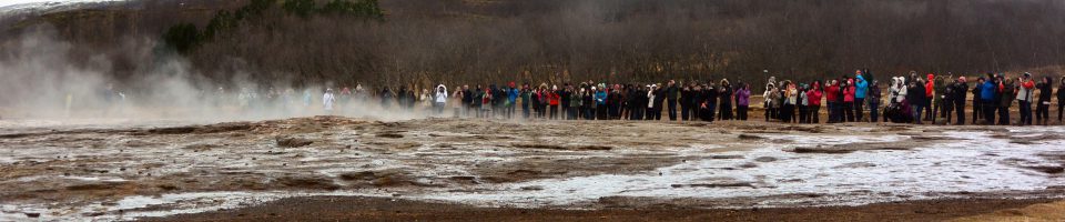
After our meal, there was one more stop on the Golden Circle route we wished to see.  It is a tiny town called Geysir, and happens to be the source of the word geyser in English.  Unlike the well-known “Old Faithful” in Yellowstone National Park in the USA, the Great Geysir in Iceland is very unfaithful.  It has been gushing forth (geysir comes from the old Norse “geysa”, “to gush”), for about 10,000 years.  Sometimes it blows about every thirty minutes.  Sometimes a few years go by without any eruptions.  Engineers have learned to trick it into erupting, and can use their engineering magic to make it erupt on cue.

The Geysir erupts.

In Iceland, safety is a suggestion. A mere rope and little sign tell one to not step in the boiling cauldron.

In a superheated pool, the water and steam flow out, and sinter, the gray silica depost, forms around the edges.

The distant volcano lies waiting, while the ground bubbles up with the heat from inside the earth.

We returned to our cabin near Selfoss, having fully explored the Golden Circle area.  We sent a couple out to the supermarket, bought some lamb and vegetables, some salad makings, and some snacks.  We made a delicious dinner and chatted about our adventures.  The next morning, we made use of the shower in the cabin.  It was located in the entryway, a space heated by a plug-in free standing oil heater which was definitely up to the task.  The shower was a rustic design, a pipe going up to the shower head, and a corrugated side panel as the wall.  We packed up after breakfast, cleaned up the cabin so we would be looked upon as worthy renters by the AirBnB owners, and headed out for our next stop.  Coming up, riding Icelandic horses, an watching icebergs flow out to sea, all in Part 2.

Frank, Michael, Lynne and Kathleen saying so long to the cabin near Selfoss.


Train in Missoula

Missoula, Montana has a nice ring to it.  A bit alliterative, it is a slightly liberal town in an otherwise very conservative state.  The region of Missoula is a relatively flat area which was once a glacial lake.  Remnants of that large lake exist today, in Flathead lake and Lake Pend Oreille.  As long as 12,000 years ago, people inhabited this area, including Salish, Kootenai, Pend d’Oreille, Blackfeet and Shoshone tribes, although known settlements date from around 3500 BCE (Before Common Era).  French fur trappers discovered it and found that they were not necessarily welcome.  In fact, the eastern valley entrance to the region was referred to as the “Porte d’Enfer” or gate of hell, due to the many human skeletons lying about from killed trappers and explorers, and aboriginal people embroiled in battles.  Lewis and Clark explored this area in 1805.  By 1860, a small settlement was established five miles west of present-day Missoula, with the name Hell Gate Village.  In 1866, the center of town moved east five miles to be closer to a water source for lumber and flour mills.  The name Missoula comes from a Salish word, “nmesuletkw”, apparently pronounced “Nemissoolatakoo”, and meaning “the place of frozen water”.  The area was seen as an ideal route for a train to pass through to the west coast.  In about 1870, construction of the Northern Pacific Railway began and the final golden spike was driven by Ulysses S. Grant in Western Montana, September 8, 1883.  It extended from the great lakes through Missoula and ended at Puget Sound near Takoma, Washington.  The story of the railroad is filled with adventure, hardship and conflict.  The railway led to rapid development along the entire line.

Missoula was granted the right to become the home of the University of Montana by agreeing not to challenge Helena to be the state capitol.  It was established in 1893 on land on the south side of the Clark Fork River.  When I visited in June, 2016, I was told by a number of locals that the university is what makes the town different from other places in Montana.  Of particular note, the first woman elected to US Congress was from Missoula.  Jeannette Rankin, born in Missoula in 1880, was elected to congress in 1916, before women had the right to vote.  She was a pacifist, and during both her first term, and again after election again in 1940, she voted against entering the first world war and the second.  She stated that she could not go to war, and so she would not vote to send any one else.  She was a fighter, though, for the right for women to vote.

I and my whole extended family traveled to Missoula in June, 2016 for the wedding of my nephew, Greg.  I had not been to Montana before, and did not know what to expect.  While there is an airport in Missoula, my wife and I decided to fly in to Spokane, at the eastern edge of Washington.  We drove north from Spokane, around the northern shore of Lake Pend Oreille and the town of of Sandpoint, Idaho.  From there, we drove southeast, following the course of the Clark Fork river all the way to Missoula.  This is a beautiful drive, with scenic mountains in the background, some snow-capped, and the rushing river to our right.

Scenic view of Clark Fork River upstream from Missoula.

Scenic view of Clark Fork River upstream from Missoula.

Even though Greg would be getting married in a couple of days, he was very happy to go for a run with me the morning after we arrived.  Our first run was along the Clark Fork river, and past the campus of the University of Montana, home of the “Grizzlies”.  There is a nice trail along the river which goes for miles, and makes for a great running trail.  There is a very large “M” on a hillside above the campus, with a switchback trail leading up to it.  It is a favorite of visitors to the campus to go for a hike up this hill.  We, my family, considered it, but thought it looked a bit unrewarding just to go see the “M”.  We still wanted to enjoy the trails around Missoula.

University of Montana "M" trail.

University of Montana “M” trail.

Instead, we decided to climb up Waterworks Hill, a not-too-steep trail on the north side of Missoula overlooking the town.  We all gathered together, no small feat for us, and headed through town to the base of the trail.

At the entrance to the Waterworks Hill Trail.

At the entrance to the Waterworks Hill Trail.

The trail goes up a rolling set of hills, with grass and native flowering plants along the way.  One gets the feeling this is a sensitive ecologic zone.  The hillside is covered with these plants, but if they were not there the whole side of the hill could come sliding down in a heavy rain and inundate Missoula.  It is also a risk for avalanches onto the the homes below during the winter months.  Sheep are used at various times during the year as a means of keeping some of the invasive species down.  How the sheep know the right plants to eat, I am not sure.   As we ascended, the surrounding hills came into view.

On the way up Waterworks Hill.

On the way up Waterworks Hill.

A few man-made objects presented an opportunity for the group to look like the cast of a Shakespeare Play.

The cast of the play.

That guy in the middle is the main character.

Nearing the top of the first hill, one is greeted with a great view of Missoula and the surrounding mountains.

Missoula as seen from Waterworks Hill.

Missoula as seen from Waterworks Hill.

This brings me to my main topic.  One can see the train stretching across the scene in the photo.  Trains of several hundred cars up to a mile and a half long pass through Missoula many times a day.  When the Northern Pacific Railway began, the freight was wheat, farm equipment, and passengers.  Since 1970, it was incorporated into the conglomerate known as Burlington Northern, and it carries a different cargo today.  On our way back into town, we were stopped by the train heading eastward back to its origin.  Empty coal cars rattled and screeched as the train passed eastward through the town, and automobiles idled at the railroad crossing.  Finally, the caboose was in sight, passed by, and the gates opened.  I was moved to find out more about these trains and their cargo.  I asked my cousin, George, who moved to Montana a few years ago from Los Angeles, and now lives in Missoula.  He told me the trains were coming from Wyoming, from an area called the Powder River Basin.

Pronghorn, Bison National Reserve, Montana

Pronghorn, Bison National Reserve, Montana

The Powder River Basin is a geologic area in southeast Montana and northeast Wyoming, 200 by 120 miles in size.  It is the largest coal mining area in the United States, and produces a type of coal called sub-bituminous.  About sixty million years ago, this region was largely a shallow sea, and received three meters of rainfall per year.  There was a large amount of plant growth, and due to the geography, dead plants did not wash away.  Instead, they became peat bogs which were eventually crushed under dirt and rock to become coal, as the region dried up.  It is estimated this area contains enough coal to light the U.S. almost to the twenty third century.  It was not of great importance compared with coal from Appalachia, until concern was raised about sulfur dioxide, or SO2.  The coal from this region produces about 8,500 BTU’s per pound, versus 12,500 BTU’s per pound for Appalachian coal.  But the SO2 content of the Wyoming coal is very low compared with the coal from Kentucky and West Virginia.  Sulfur dioxide is widely used as a food preservative, in wine making, and in medicine.  It is considered safe for human consumption, except for young asthmatics in whom it may precipitate an attack.  It is a part of normal plant and animal physiology.  However, released into the air from burning coal, it can become sulfuric acid, the cause of “acid rain”.  As acid rain became recognized as a serious threat to the environment, the US government in 1995 developed the Acid Rain Program, a market-based approach to reducing SO2 emissions.  This made coal from the Powder River Basin very competitive with Appalachian coal, since “scrubbing” costs were much less to burn Powder River Basin coal, even though it had less heat output.  The coal in this area is mined by strip mining techniques, and it is done on a very large scale.  An overview in a website called The Daily Climate describes the operation very well.  Of the one billion tons of coal used each year in the United States, about 400 million tons comes from the Powder River Basin.  The amount exported to Asian ports is relatively small, around 10-20 million tons per year.  However, the price offered can be up to ten times the domestic price of about $10 per ton for Powder River Basin coal.  The cost to the mine companies, though, is very cheap.  The coal is owned by us, the people.  It is sold via the Bureau of Land Management to the coal mining companies for around 20 cents per ton.  Since the price received from Asian countries is quite high, as high as $100 a ton in the last few years, the mining companies are doing quite well.

missoulatrain960x200

Like all energy production, though, these prices can change radically and quickly.  If China or India slow their use of energy due to a cooling economy, as has happened over the last two years, the production of coal exceeds demand.  Also, if prices are high, other producers around the globe including Australia, Russia, Indonesia, India and South Africa up their production.  All this has happened resulting in lower prices for coal in the Pacific Rim.  However, as seen by the steady train traffic through Missoula, the coal from Powder River Basin, because of its low sulfur content among other attributes, is still considered desirable, and is still being exported.  One of the factors in exporting this coal is the limited port availability near San Francisco, Portland, Seattle and Vancouver.  These areas are reluctant to invest in increased port capacity due to the market volatility.  Other factors influencing the building of these facilities include the rights of native American tribes.  In some cases, the tribes come down on different sides of the argument.  Producers of the coal feel limited by the port capacity, and would like to see it increase.  Of interest, too, is that while a large amount of coal is exported from the Powder River Basin, it is a tiny fraction of the coal imported to China, South Korea, and other parts of Southeast Asia, currently about 4% of these area’s imports.  While coal demand in the US is falling due to the increase in natural gas from new production, it is difficult to transport gas overseas, and so coal use is still a major source of energy in Asian countries.

Naturally, Missoulans and others on the paths of these coal trains are concerned about the environmental impact.  There have been a number of protests in Missoula like that seen in the video below.  Diesel fumes and dust from the coal cars are concerns.  The Army Corps of Engineers has been tasked with studying the environmental impact of the train traffic through these areas.

I knew nothing about the Powder River Basin, and very little about coal, before researching this topic.  As I dug deeper into the issues surrounding the use, mining and transport, and sales and world market for coal, the issues and side branches of this topic became exponentially more complex.  I do hope Missoula stays as livable and beautiful a place as it was for my very short visit in June.  For anyone who wishes to do their own reading on this interesting topic I have listed a few of the resources I used.

A very informative and detailed analysis of coal exports from the US, by Sylvie Cornot-Gandolphe, Research Associate at the Oxford Institute for Energy Studies:  https://www.oxfordenergy.org/wpcms/wp-content/uploads/2015/03/CL-21.pdf

U.S. coal prices by region, from U.S. Energy Information Administration data:  https://www.quandl.com/data/EIA/COAL-US-Coal-Prices-by-Region

U.S. Energy Information Administration coal export analysis:  https://www.eia.gov/todayinenergy/detail.php?id=11791

The Daily Climate essay with impressive photos on the Powder River Basin and coal production:  http://www.dailyclimate.org/tdc-newsroom/2013/12/western-coal-development

Wikipedia articles on Sulfur Dioxide and Acid Rain:

https://en.wikipedia.org/wiki/Sulfur_dioxide

https://en.wikipedia.org/wiki/Acid_rain


Uncorking Croatia

The Blog of WINES OF CROATIA

RunnersOnTheGo.com

To help enrich the lives of others, we developed RunnersOnTheGo.com to help runners save money on races, running stores, and much more. We also provide the specific local information that makes your travel for business, vacation, or racing as rewarding as possible.

getsetandgo

Travel Blog of a Budget Traveler sharing stories on travel, books & Vegetarian Food

Marc Hemingway

Trying to keep track of my life (and my life on track)

Mid-Life, Mid-Level, Masters Running

Exploring ideas about running to contribute to a more enjoyable pursuit for the mid-level masters runner

therunningtherapist

"One foot in front of the other and one thought at a time"

WordPress.com News

The latest news on WordPress.com and the WordPress community.

retireediary

The Diary of a Retiree

%d bloggers like this: