Fire, Ice and Trolls, Part 3

pirateandtraveler.jpg

Map from Pirate and Traveler

Decades ago, when my brother and I were kids, there was a board game we played called “Pirate and Traveler“.  The fact I still remember it today says something, that it stimulated a desire to travel the world, and a curiosity about foreign lands.  One of the destinations one could travel to in this game, was the city of Reykjavik, on a tiny island between Greenland and the British Isles.  We, my brother and I, always got a kick out of trying to get to Reykjavik, and figure out how to pronounce it.  No one we knew seemed to know, nor had they been there.

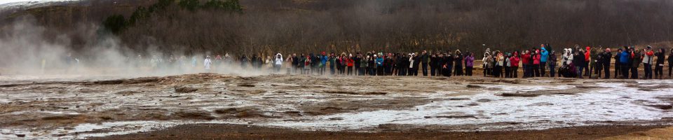
Today, Reykjavik is a hot destination.  Tourism has become the number one industry in Iceland, outpacing fishing and manufacturing since 2010.  As documented in this report from 2015:  “Iceland and the Trials of 21st Century Tourism” the concern is now that the numbers of tourists visiting Iceland today is having enormous and perhaps negative societal and ecological impacts.  Mentioned in the report is that Airbnb has been a major part of Iceland’s ability to accommodate so many tourists.  While the whole country has 350,000 people, most of whom live in Reykjavik, the annual tourist visits today are three times that, and growing.  The hotel industry is growing, but without Airbnb, Iceland could never house all those people.

This has been good for Iceland.  In the great crash of 2008, Iceland suffered as if a volcano had blown and destroyed the nation.  Due to extremely poor, and in many cases criminal, mismanagement of the private banks and their debt, the country fell into an economic crisis from which they are slowly but steadily crawling out.

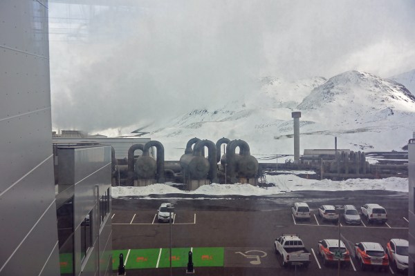
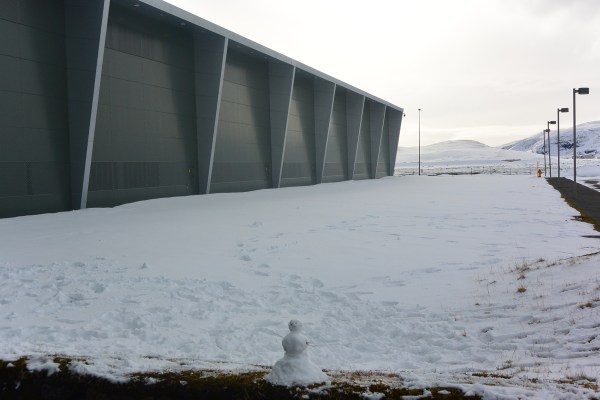
What is Reykjavik like today?  It is an incredibly modern, forward thinking and ecologically conscious city.  While we flew into the airport at Keflavik, the main international airport for Iceland and near Reykjavik, we spent no time in the city until the last two days of our trip.  We drove back from Vík í Mýrdal through Selfoss, and then up a long steady climb through a mountain pass.  The scenery changed from grasses and moss-covered lava, to snow, very white and glistening snow in all directions.  We were on our way to visit the Hellisheiði Power Station, a geothermal power and hot water generator situated over an active volcanic ridge.  Thirty wells, 2000-3000 meters deep, extract steam from fissures in the rock, which provides steam to generate electricity and also hot water which is used to heat homes and businesses, and even some sidewalks in Reykjavik.  The superheated water is carried by high-tech pipes to the city and distributed by smaller pipes.  This and one other similar plant provide all of Reykjavik’s needs.  They are justifiably proud of their facility, and provide self-guided tours of the plant, with large diagrams and explanations of the complex operation.

P1010012a

Entrance to Hellisheði Geothermal Power Station

DSC_1578a

steam separators at the power station

DSC_1579a

Steam driven turbines producing electricity.

DSC_1577a

Display of minerals found around the power station.

DSC_1582a

Icelanders have a sense of fun.

Moving on.  We drove on to Reykjavik and found our way to our hotel.  We stayed at the Fosshotel Reykjavik.  Here’s the address:  Þórunnartún 1 – Höfðatorg, Reykjavik.  I added that just so you can see how challenging Icelandic can be.  The hotel was wonderful.  The room was very comfortable, and we had a view of the bay.  The bathroom had a heated floor, due to the piped in hot water from the power station we just visited.  A feast of a breakfast was included, and it was beautifully presented.  There was a very good automatic coffee machine so one could get one’s choice of coffee style.  There was also an excellent beer bar with a happy hour which served many local craft brews, which turned out to be delicious.  We were within walking distance of the main shopping and dining street, Laugavegur.  For our brief stay in the city, we chose to visit the National Museum of Iceland, the Settlement Exhibition, and the Reykjavik Maritime Museum.  The National Museum had many items to explore, particularly from the geological and anthropological perspective.  This includes bones of an ancient Viking skeleton and  a rather complex loom demonstrating how early settlers made cloth.  One very interesting exhibit from my perspective, was an analysis of the DNA of Icelanders.  A company called deCODE Genetics in Iceland, once independent but now owned by Amgen, has taken DNA samples from 160,000 Icelanders.  What makes this study unique, and very valuable, is that most Icelanders can date their ancestry to settlers from the earliest groups to populate Iceland, from 870 to about 1100 AD.  Not only that, but genealogical records in Iceland are very complete.  So, with a large database of DNA, and ways to compare with family and medical histories, there is an ideal combination of family information needed to understand the DNA results.  One fascinating finding in one of the studies shows the origin of Icelanders, with about 80% of the men having Norse genes, and about 63% of Icelandic women of Celtic origin.  One may interpret that as one chooses, but those are the numbers.  The museum had much else to offer, of Viking artifacts, furniture, and explanations of the geology of this singular island, and one could spend hours there.   We also visited the Settlement Exhibition, which is a museum housed around the ruins of an ancient Viking longhouse, discovered in Reykjavik in 2001, and inhabited from about 930-1000 AD.  The exhibit is part of the Reykjavik City Museum, but housed separately.  The theme of this museum is 871+/- 2.  One of the peculiarities of Iceland is that dates of settlements and major changes over the centuries can be related to tephra, which is ash layer that falls from volcanic eruptions.  Around 871, with a 2 year plus or minus range, a large eruption produced enough tephra to cover much of Iceland, and part of the wall of this exhibit was covered with tephra from 871.  It was very interesting to walk around the longhouse, examining the old walls and artifacts.

Restaurants in Reykjavik tend to be expensive.  A mid-price restaurant will run 3,000 to 6,000 Krónur, or about $30-$60 per person, not including drinks.  We chose a nice place called Apotek, a very forward thinking, creative restaurant with an Argentine chef.  Our dinner was excellent, and I can highly recommend this place.

On our second day in Reykjavik, we headed to the Maritime Museum.  While not on the top lists of museums in this city, and a bit on the edge of town, it turned out we learned a great deal here and considered the effort to find it very worthwhile.  It is all about the fishing industry in Iceland, from the early days of fishing for cod from simple rowed boats, with hand lines, to modern techniques of enormous fishing vessels which process fish as it is hauled aboard by giant trawler nets pulled in by diesel engines.  We learned of the Cod Wars, which took place over the late 1950’s to 1976.  These were confrontations between the United Kingdom and Iceland over fishing rights, involving warships in addition to fishing vessels, and resulted in the expansion of Iceland’s fishing rights to a 200 mile zone.  They are very complicated struggles, which involved NATO, African Nations, Russia and Europe, and even led to political science studies, as well as a report by Henry Kissinger.  Follow the link if you are curious.

DSC_1584a

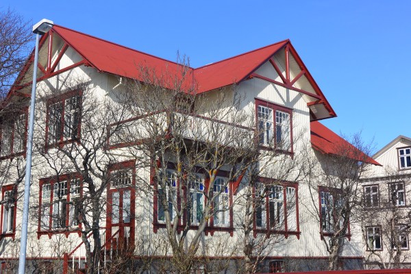
A stately house in Reykjavik.

DSC_1583a

Wandering about Reykjavik on a chilly but sunny day in March.

DSC_1597a

Fishing is still very important in Iceland, and from the looks of it, it hasn’t gotten easy.

This is supposed to be stories about running, given the name of my blog.  After strolling about, admiring the structural integrity of the houses and other buildings in this city, meant to stand up to vicious weather, grabbing a bite in a public park at a fast food kiosk, watching young children running about, we realized we needed to get back to our car to feed the meter.  Hence, the first of my runs in Iceland.  My friend and co-traveler Michael and I had worked this out.  Should we need to get back to the car before the meter expired, I would hand off my backpack to Michael and run to where we had parked, so to feed the meter.  Well, the moment came, and I did exactly that,  I think it was about 1.5 km, but it was a run.  I made it to the car in time, no meter maids were in the area, and I was able to get my credit card out, work the machine, get the slip to put on the dash, and protect us from what would surely have been a hassle from our car rental company.  I met up with my wife and friends, and we headed back to the hotel for a nice beer at the beer bar.  Later, we went out for another restaurant experience.  This was not quite as nice as the first night, in a place with loud music and tight seating.  I’ll not warn you away from this restaurant, but there are many excellent restaurants in Reykjavik from which to choose.

Our last morning before leaving, it was snowing lightly and a bit windy.  We took a walk along the bay, on a path built for strolling, running, cycling or whatever.  The walk was dotted with statues and tributes, to Vikings, to USA-Iceland friendship, and just to art.

DSC_1586a

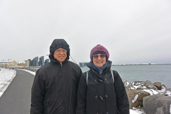
Michael and Lynne, dressed for the weather.

DSC_1589a

Kathleen, with the bay of Reykjavik looking very frigid behind her.

DSC_1587a

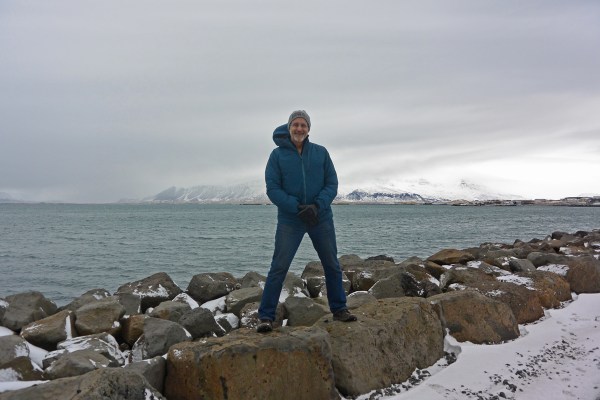
Frank, pretending he’s a Viking.

DSC_1593a

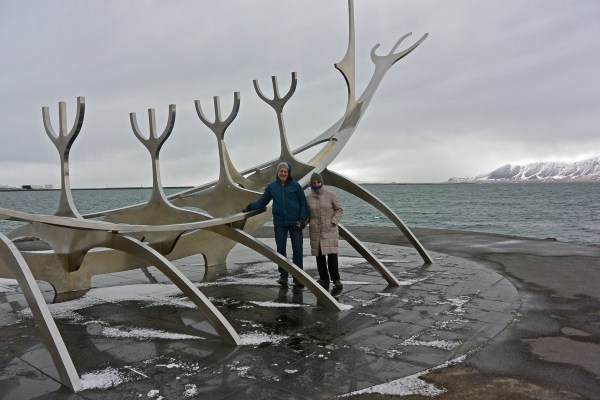
An homage to the Viking past of Iceland. The ground was extraordinarily slick with ice, and this photo was a risk.

DSC_1590a

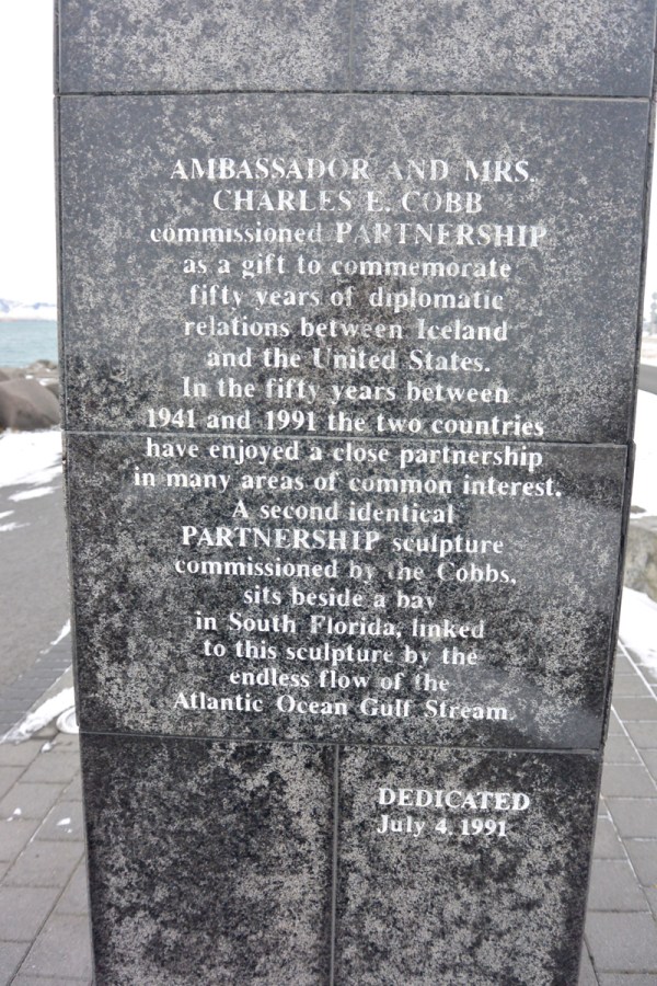
Back when diplomats were diplomatic, and reason prevailed, this sentiment carved in stone makes a beautiful statement

DSC_1592

Art for art’s sake, along Reykjavik bay.

We wound up our stroll and headed back toward the hotel.  On the way, we stumbled upon the one place in Iceland where we met people who spoke only Icelandic.  It was a bakery, the oldest in Iceland by the sign, and it served absolutely delicious pastries and sandwiches.  We had a couple of croissants, and some sandwiches for the plane.

DSC_1598a

While the sign may be in English, the bakery personnel don’t speak English. Not a problem, though, pointing works very well.

There was one other run.  We got to the airport in plenty of time.  We were on Wow Airlines, a budget carrier, but very efficient at moving people through their system.  We made it through security, passport control, the enormous duty free shop, and to the waiting area at the gate.  I had a hunch, though, that something was missing.  Looking in my backpack, I realized that my iPad was missing.  I figured I must have left it at the security area, since I had gotten waylaid by the agents who selected me for a random search of everything.  I bolted back, through the duty free shop, up an empty stairway, found a locked door, back down the stairs, finally found my way to the passport control, ran through there, then back the long haul to the security area.  I went to the aisle I had gone through, and spoke to the agents.  I, somewhat short of breath, explained my plight, that I thought I left my iPad when passing through.  At first they looked at my as if to say, sorry man, that’s not our problem.  Then, one of them spoke up, and said he thought he knew where it was.  It had been taken to the manager’s office.  He retrieved it for me.  Thanking him profusely, I started my run back to the gate, through passport, getting my passport stamped twice for leaving Iceland, and made it back to the gate with a few minutes to spare before boarding.  We had a very nice flight back to the USA.  We fortunately were sat in emergency exit seats, with plenty of stretch room in front of us.  I bought a $7 Heineken, and enjoyed the time in the air, and the sandwich I had bought at the bakery.  I would go back to Iceland in a flash.  There is so much more there to explore, and it is a fascinating and adventuresome place.  We’ve seen the major attractions of the southern part, but we didn’t get to see the northern lights, and there’s plenty to do in the northern reaches of the country.  Also, I’m sure there are some excellent microbrews I have not tried yet.

Fire, Ice and Trolls, Part 2

Reynisdrangar, basalt columns off the coast at Vik í Mýrdal in southern central Iceland

Reynisdrangar.  Right off the water’s edge from Reynisfjall.  Two trolls were pulling their three-masted boat in, but it was slow going because of the rough seas.  Unfortunately, they got caught out in the water as the sun rose, and being trolls, this turned them to stone.  And, there they stay, out in the water, forever.

Vik is not a large town.  In fact, only about 300 people live here full-time.  This was our next destination on our tour of Iceland.  We left our cozy little cabin near Selfoss, put some diesel in the Skoda, and headed out along Iceland 1, the ring road that runs the circumference of Iceland.  Along the way, passing through Hvolsvöllur, we happened to see a sign on the road for the “The Saga Centre”.  As we drove by the sign, I asked my traveling companions if they would like to stop and check it out.  Yes, was the reply.  So, we turned around and searched for it.  It was not immediately obvious, but hunting off the main road took us to the low building with a painting of a viking ship, vikings with swords raised, on the side, and there we were.

The Saga Centre

Inside, a very nice woman explained the exhibit.  We paid the entrance fee and explored.  The Centre is devoted to telling the story of Njáls Saga, or the Story of Burnt Njáll.  Yes, Njáll meets an unpleasant end, but a lot happens in this, the most famous and one of the earliest of the Icelandic sagas.  It is a story first written down by an unknown author between 1270 and 1290, but taken from oral stories of early families, mainly concerning the sagacious Njáll and his friend the strong warrior Gunnar.  It is a long and complicated work.  The museum shows the saga from start to finish in dioramas with life-sized figures, dressed in period garb, with the writing in Icelandic and English, and allow for an understanding of the flow of the saga, the feuds, the insults, the vengeance, the trickery, the lustiness and the struggles of every day life in early, Viking-style Iceland.  After making our way through Njáls Saga, we moved to the mock-up of a Chieftain’s Hall, a meeting area built by the Vikings in early times.

Viking-era Chieftain’s Hall at the Saga Centre.

Today, it is used as a café, and is rented out for functions.  Beyond this, was another hall in which there was an intriguing project taking place.  It is called the Njals Saga Tapestry, and it is the work of three women who designed and created a 90 meter long tapestry in which panels depict the entire story of Njáls Saga.  It uses a Bayeux stitch, which was a type of tapestry stitch used in Viking times.  According to Christína, one of the creators of the project, 60 meters have been completed so far.  She is not certain where such a big artwork will be displayed.

Christína and her Njáls Saga Tapestry


One of the panels of the tapestry. The pinned papers show the name of the person working on that panel.

Once we had finished contemplating life in the time of Njáll, we sat outside and ate sandwiches we had prepared that AM.  It started out sunny and warm, but had turned cold and overcast, so we hurriedly finished and then went on driving towards Vik.  One thing in Iceland one can count on is the presence of waterfalls.  Our next stop was at Seljalandsfoss,  where water from the above plain and glacier plunge 60 meters to the flat land below.  A unique feature of this waterfall, is the footpath that leads behind it to a cavernous space from which one can witness the backside of water.  I came prepared for this.  I wore my waterproof jacket and ski pants, had my hiking boots on, and kept my camera under my jacket until I got around to the back.  There was a good breeze blowing, spraying water over the path which made it slippery.  I managed the path, and had a big grin on my face once I got to the relative protection of the cave.

Seljalandsfoss from the front.


Seljalandsfoss from behind (the backside of water).

A bit of a hike down the path was another waterfall, Gljúfrabú¡, also very dramatic, and hidden behind an opening in the cliff.

Gljúfrabú¡, the hidden falls near Seljalandsfoss


A sheep carcass along the path, in its “pre-fossilized” state.


Kathleen and Lynne, walking along the runoff from the falls.


The big picture view of the Seljalandsfoss area.

We then went on to Vik, and to our next Airbnb rental.  As we neared Vik, we climbed over a mountainous pass which then descended into the town.  It is a tiny town, with a population around 300.  But, being the only town of any size in this area, it is well stocked.  There is a nice grocery, a bank, and a liquor store.  Our rental was easy to find, as it was right off the main highway, and looked just like its photo on the website.  Once we made it into the apartment, we headed on foot to the store to gather up some wine, beer and hors d’oeuvres.  Our whole group of nine intrepid explorers were coming over to our place to eat, drink and chat about what we had seen and done so far.

Frank, Lynne, Bob, Gary, Niny, Kathleen, Michael, Sue and Ann; in Vik.

We prepared some Icelandic crustaceans similar to crayfish with seafood sauce, had locally produced salami and cheeses, and Kathleen made a delicious yellow split pea soup for some honest sustenance.  Grapes and Finncrisps topped off the delights.  There was no need for dinner that evening.

Overnight, it snowed.  According to one source, Icelandic language has 100 names for snow.  Snow is certainly part of their culture.  It made for a difficult drive the next morning.  While the road crews did plow the road, is was still very slick for the first third of the drive.  Our destination was 192 km away.  The drive got much better after we passed Kirkjubærklaustur.  The snow was gone, and traction returned. We were on our way to Jökulsárlón, a glacial lagoon with a rapidly running, short river to the sea.   Along the way, we crossed a number of one lane bridges, where, if no one is approaching it is clear sailing.  Otherwise, you give the other driver the right of way if they reach the bridge first.  No playing chicken, since the downside is a cold river.  The glacier, Breiðamerkurjökull, is a tongue of a larger glacier called Vatnajökull.  It has changed dramatically over the centuries.  When the Vikings first arrived, the edge of the glacier was 20 km from the ocean.  During the little ice age of 1600-1900, the glacier extended almost to the ocean.  But over the last 100 or so years, it has receded, and now is about 6 km from the ocean.  The glacier hangs into the lagoon, and large pieces of it break off and float in the lagoon.  As we arrived, we stayed away from the main parking area and gift shop, and parked in a small lot close to some hills surrounding the lagoon.

Ascending the gravelly hill overlooking Jökulsárlón.

We were amazed by the view.  To the left was a mountain range, part of a large national park in this part of Iceland.  Directly to the north, there was the immense glacier, with its edge dropping into the lagoon.  And the lagoon itself was filled with large chunks of ice which had broken free of the edge of the glacier.  They would eventually make their way to the sea.

The mountains of the Vatnajökull National Park


The Breiðamerkurjökull (glacier) at the far side of the Jökulsárlón (lagoon).


Tracks from giant-wheeled four wheel drive vehicles are evident on the glacier, where expeditions of tourists go to explore the surface.  We moved down to the shore line of the lagoon.

Heading to the shore line of the Jökulsárlón.


Bits of the glacier had landed on the rocks, forming interesting artistic pieces.

We had gotten a tip from a local in Vik that we could break off pieces of ice from the glacial ice and taste it.  That we did.  It was crystal clear and tasted fine, and, glad to report, did not cause any illness.

Frank and Kat, exploring along the edge of the lagoon.

You may notice that a lot of the floating ice contains layers of black.  These are layers of volcanic ash which coated the glacier over many years.  The amount of ash differs from eruption to eruption, so glaciologists can determine the age of the ice based on the volcanic ash layer.

Glacial ice with volcanic ash layers.


Rocks and pebbles deposited on the shoreline by the glacier.

We then drove to the beach where the outlet river met the ocean.  After almost getting trapped in a low, icy patch, we managed to park safely and got out to wander amongst the beached icebergs.  The beach, a black sand and gravel beach, had dozens of icebergs to wander around, and dozens of tourists doing just that.

Some icebergs made it out to the ocean.


Beautiful translucent blue of a slowly melting iceberg, with birds circling behind.


Some icebergs got stranded on the sand.


We were able to walk around the stranded icebergs.


The outflow of the lagoon, rapidly running water and jammed up icebergs.

As we looked at the glacier, and the large chunks breaking off and floating by, I thought of Sveinn Pálsson.  Who, you say?  Sveinn Pálsson was a Dane, trained in Copenhagen to be a physician, who came to Iceland in 1791.  His home, a farm, was near Vik.  He was the only physician in a large part of southern Iceland, where travel was very difficult due to the many rivers and lava fields in this area.  He was also a naturalist, farmer, fisherman, father of 15 children by wife Þórunn Bjarnadóttir, 10 of whom survived infancy.  He studied glaciers and volcanoes, and was the first person to propose that glaciers move by “creep, analogous to the flow of pitch”, per the Wikipedia article about him, which was the only source I could find.  He wrote a treatise and submitted it to the Danish Society of Natural History in 1795.  It remained unpublished there until 1880, when part of it was published.  The whole treatise was finally published in Icelandic in 1945.  He also wrote extensively about medicine.  He must have been an amazing, brilliant and very tough person who loved life.

We could not get enough of watching the water sluice around the ice, staring at the many shapes and sizes of icebergs, and the beautiful views of the mountains and glacier in the distance.  But, eventually we tore ourselves away and headed back to Vik for the evening.  On arrival back at our apartment, Michael and I walked down to the grocery store intending to buy some lamb to cook for dinner.  The meat section had a variety of cuts from which to choose, but all labeled only in Icelandic.  We stood there, picking up packs of meats in one hand, our phones and Google translate in the other, trying to figure out what animal these cuts had come from.  None seemed to match the word “lamb”, “lambakjöt”.  But the  words written on the packages kept coming up with no translation.  We made a choice based on looks alone, bought some carrots, onions, mushrooms, potatoes, and salad makings and headed back.  We had a delicious dinner that night, enhanced by the collection of spices available in our apartment, but in no way was it lamb.  It may have been veal, but no one was certain.

The next morning, Kat and I had planned to ride the Icelandic horses on the beach.  In Vik, there is a stables which advertises horse back rides on the black sand beach of Vik.  We made a reservation before our trip with Vik Horse Adventures.  Early that morning, I got up ahead of everyone else, like I usually do, and made some coffee.  I was cleaning a beer glass from the night before, a very thin, narrow glass, which broke in my hand as I was washing it.  Suddenly, there was blood all over the sink, and I looked at my hand.  I saw a very neat slash at the base of my fourth finger, down to the tendon, bleeding profusely.  I applied pressure with a paper towel, cleaned up the blood as well as I could, and sought the help of Kathleen.  We were able to fashion a nice, tight bandage of paper towel and plastic wrap, which stopped the bleeding and seemed to keep everything under control.  I did not want to miss the opportunity to ride the Icelandic horses.  These are a unique breed.  Their ancestors were brought to Iceland in the early days of settlement, 870 to 1100, mostly from Norway, but also from Scotland and the Shetland Islands.  After that, no new horses were allowed into Iceland.  The characteristics of the breed developed from selective breeding and from natural selection, creating the breed as it exists today.  It is known as a strong breed, well adapted to the weather and geography of Iceland, and also as a five-gaited horse, with two gaits which many other horses do not have.  These are the tölt and the skeið.  These are unusual, flowing gaits not usually seen in domestic horses in the USA.

Hjördis readying the horses at Vik Horse Adventure


Frank and Kathleen riding Icelandic horses on the black sand beach covered in snow in Vik.


Heading out on our ride.

We rode along a path which led to a little stream.  We forded the stream, which was fast running and came up to the bottoms of our shoes.  The horses seemed comfortable in the frigid water.  Crossing to the other side, we headed for the beach and the black sand.  There, we were able to get, briefly, into a tölt, which, while slow by tölt standards, felt fast and remarkably smooth.  We could not go for long, due to the snow, which would pack into the horses hooves and cause them injury.  Nevertheless, it was a remarkable experience on beautiful and unique horses.  Getting back to the stables, I had to take my horse on a few more turns around the paddock.  Reluctantly, I dismounted, removed the bridle and saddle, and turned the tack over to Hjördis, promising I would be back for some more riding.

My wife, Kathleen, and I then met up with Lynne and Michael.  We took the road up to the Church overlooking the town of Vik.  Vik is, for the most part, low and close to the ocean.  High above it is the massive Mýrdalsjökull, an enormous glacier which covers the Katla volcano.  Should the volcano blow, it could melt enough ice to flood the town of Vik.  So, they have regular drills in Vik when everyone in the town gets themselves up the hill to the church, the only building in the area which could potentially survive such a flood.  This in mind, we headed out of town, towards Reykjavík, and part three of our saga.

Fire, Ice and Trolls, Part 1

At the entrance to the Blue Lagoon.

Everything I tell you is true.  This is the way it happened.  So began one of many sagas we would hear in Iceland, this one coming from Christian, the owner of a small café called Café Bryggjan.  Bryggjan means “pier” in Icelandic, and this fisherman’s café is in a small seaside town called Grindavik at the water’s edge of a harbor.  After landing at the main Iceland airport in Keflavik at around 4:45 AM, we got through customs very quickly, picked up our bags, and got our rental car.  I rented from Budget, yes, the same as in the USA.  Our car was a Skoda, made in the Czech Republic, very comfortable, well-built, full-time four-wheel drive (important in Iceland), and large enough for four with our suitcases.  It happened to be a diesel automatic.  We then drove off to find our way to Grindavik and the Bryggjan Café.

You may wonder, as I did, why many place names in Iceland end in “vik”.  As it happens, “vik” means “bay, inlet or cove”  in Old Norse.  So, Reykjavik is Reykja Bay, and so on.

When we arrived in Grindavik and found our way to the restaurant, we were impressed by the plainness of the buildings, and the location of the restaurant, practically at the edge of a large harbor.  We, the four in my group, and the rest of our group, another five traveling with us in another car, met up at the café.  They had rented the very same Skoda we had.  Popular car, that Skoda, in Iceland.  The café was still closed, as it was only 6:30, and it opened at 7:00.  There was another couple waiting for the place to open, a mother and daughter traveling together.  We chatted a bit outside, checked the hours on-line to be sure we were not mistaken about it opening on Sunday, and milled about for a while.  It was cold, slightly raining and windy, so before long, our group made their way back to the cars to sit out of the weather.  Then, a slightly portly looking gentleman dressed in clothes more appropriate for a warm spring day, headed to the back door and opened up the restaurant.  He was very friendly and welcomed us all in.  He explained there were two breakfast options, the light plate, and the full fisherman’s breakfast, which included smoked fish in addition to Icelandic bread, butter, tomatoes, cucumbers, sliced ham and sliced cheese.  Coffee was in the works, and we were also offered Skyr, the Icelandic version of Greek style yogurt.  After all the breakfasts were served, Christian, the owner, came to the center of the room, and started to tell us of the history of the building, the fisherman and the fishing boats, showed us photos on the walls of many boats which had sailed from Grindavik, some of which had not returned, and of course, explained a lot of accidents and incidents as the work of trolls who play a large part in the folklore of Iceland.

In the Bryggjan Café

In the Bryggjan Café

Christian and Gary at the Bryggjan Café, Grindavik

Iceland is a hard place to live.  It is a volcano, or multiple volcanoes.  By one Icelandic blogger’s account, Jón Frímann, volcanic eruptions have occurred over 160 times from 870 to 2014.  Some have been little puffs and some major eruptions.  Iceland was created by a “hot spot”, where lava flowed from out of a crack in the floor of the ocean, at the junction of the Eurasian and North American tectonic plates.  This is the same manner in which the islands of Hawaii were created.  In Iceland, when the volcanic activity has calmed, glaciers form over the calderas of the volcanoes.  When they blow, heavy volcanic ash rains down destroying living things, and the glacier becomes a massive flood flowing down to the sea.  So one might wonder, what attracted the Vikings to this little island?  The story of the Icelanders, how Iceland was discovered, who first settled, and the history of the country is documented from early on in sagas from early settlers, and from stories from the middle ages to the present day in vivid detail.  My intent is not to relate the history of Iceland, but to give a sense of our visit, what we saw, and the adventure of exploring this place.

After breakfast, we drove to the Blue Lagoon, one of the famous tourist stops in Iceland.  It’s played up as an ultimate spa experience.  In fact, it is the silica-rich water run off from a geothermal energy plant, collected in ponds created in lava fields.  The water is said to be helpful for skin conditions, and just generally a nice experience.  It is a very popular place, and one needs reservations to go.  At check in, a wrist band is provided which is used to open and lock a locker, and also to pay for food or drink.  The water is hot, but not too hot, and there are multiple connected pools to explore, as well as a bar in one of the pools from which to order a drink.

Some of our group, with their silica face paint on.

The Blue Lagoon


It is a very high-style place, with a fancy restaurant, a café, and, of course, a gift shop, selling skin products and Icelandic clothing, all at extraordinarily high prices.  But go, you will not regret it.

Skin tightened, it was time to move on to our next challenge.  We needed to find our way to our AirBnB rental.  The four in our group drove off in search of our cabin which we rented for the next two days.  It was located about 15 minutes drive north of a medium-sized town called Selfoss along the southern part of Iceland.  The owners live in Reykjavik, and use it as a getaway for themselves.  It was a very charming, small, but well-equipped cabin in the woods.  Not that there are a lot of trees in Iceland.  Apparently, there were birch forests when the Vikings first came.  Those are long gone from changes in temperature, volcanic activity, and harvesting of the trees for buildings and firewood.  We managed to find our way to the cabin and settle in.  We shopped in a large, well-stocked supermarket called Kronus in Selfoss for our meals.

Our Cabin in the Woods

Michael, in repose, in the cabin.

Kathleen in the kitchen.


The view from the cabin.

Our cabin was located within short striking distance of three of our goals for sightseeing.  The first is a fascinating place, both geologically and historically.  It is called Þingvellir (or Thingvellir, in our alphabet).  It is the place where the Eurasian and North American tectonic plates meet.  These two land masses separate from each other at 2 cm per year.  They roll like conveyor belts, and as they slowly move apart, they create fissures and cracks, and steam, lava and water move upward.  The split can be seen as a massive wall with waterfalls flowing over it, with gaps in the earth, and south of this area, the largest lake in Iceland.

At Thingvellir, the break between Eurasia and North America tectonic plates.


Another view of the split between continents.

It was cold but not frigid. Author Frank and wife Kathleen.


Looking off to the Eurasian plain.

The early Viking settlers found this area special, too.  They established a general assembly in the year 930 called Alþing (Althing), a meeting place for the chieftains of the various settlements, and the overall leader known as the “law speaker”.  Early on it was pretty crude justice, but the concept held, and this location was used until 1798.

Where the council met. Kathleen, Lynne and Michael holding court.

After thoroughly exploring the Thingvellir National Park, we drove off to our next sight, Gullfoss.  Gullfoss is a waterfall, part of what is called the Golden Circle, which is a group of sightseeing destinations popular with tourists and in striking distance of Reykjavik, where many tourists to Iceland stay.  Why do we enjoy seeing waterfalls so much?  A river, flowing along the countryside, may have bends and rapids, but the abrupt falling of water over a cliff can demonstrate the enormous volume of water moving through, and the power of that movement.  Waterfalls are dangerous, and cannot be navigated by boats.  And, they tend to be quite stunning to simply watch.

Gullfoss in March.

Gullfoss, looking downstream

Another saga, this one very recent, tells the story of Sigríður Tómasdóttir, the daughter of Tómas, whose family owned the waterfall.  Sigríður was said to have walked barefoot to Reykjavik in order to prevent the waterfall being sold to investors who wished to dam it and use it to produce electricity.  Or, perhaps not.  Apparently the legend is much greater than the real story, in which she was helpful in convincing Icelanders to keep the waterfall as a public park.  The investors actually never could put the money together to get the project going.  And Sigríður?  She got a sculpture of her visage placed at the waterfall.

Sigríður Tómasdóttir

After marveling at the dynamic waterfall, and getting cold from the now-falling snow and wind as we stood at the upper part of the falls, we walked over to the Gullfoss cafeteria and gift shop.  Of course, there’s a gift shop at every tourist stop!  The cafeteria is noted for its lamb soup, and is a nice respite when it is raw outside.  The gift shop is very well stocked, and fun to browse through.

After our meal, there was one more stop on the Golden Circle route we wished to see.  It is a tiny town called Geysir, and happens to be the source of the word geyser in English.  Unlike the well-known “Old Faithful” in Yellowstone National Park in the USA, the Great Geysir in Iceland is very unfaithful.  It has been gushing forth (geysir comes from the old Norse “geysa”, “to gush”), for about 10,000 years.  Sometimes it blows about every thirty minutes.  Sometimes a few years go by without any eruptions.  Engineers have learned to trick it into erupting, and can use their engineering magic to make it erupt on cue.

The Geysir erupts.

In Iceland, safety is a suggestion. A mere rope and little sign tell one to not step in the boiling cauldron.

In a superheated pool, the water and steam flow out, and sinter, the gray silica depost, forms around the edges.

The distant volcano lies waiting, while the ground bubbles up with the heat from inside the earth.

We returned to our cabin near Selfoss, having fully explored the Golden Circle area.  We sent a couple out to the supermarket, bought some lamb and vegetables, some salad makings, and some snacks.  We made a delicious dinner and chatted about our adventures.  The next morning, we made use of the shower in the cabin.  It was located in the entryway, a space heated by a plug-in free standing oil heater which was definitely up to the task.  The shower was a rustic design, a pipe going up to the shower head, and a corrugated side panel as the wall.  We packed up after breakfast, cleaned up the cabin so we would be looked upon as worthy renters by the AirBnB owners, and headed out for our next stop.  Coming up, riding Icelandic horses, an watching icebergs flow out to sea, all in Part 2.

Frank, Michael, Lynne and Kathleen saying so long to the cabin near Selfoss.


Uncorking Croatia

The Blog of WINES OF CROATIA

RunnersOnTheGo.com

To help enrich the lives of others, we developed RunnersOnTheGo.com to help runners save money on races, running stores, and much more. We also provide the specific local information that makes your travel for business, vacation, or racing as rewarding as possible.

getsetandgo

Travel Blog of a Budget Traveler sharing stories on travel, books & Vegetarian Food

Marc Hemingway

Trying to keep track of my life (and my life on track)

Mid-Life, Mid-Level, Masters Running

Exploring ideas about running to contribute to a more enjoyable pursuit for the mid-level masters runner

therunningtherapist

"One foot in front of the other and one thought at a time"

WordPress.com News

The latest news on WordPress.com and the WordPress community.

retireediary

The Diary of a Retiree

%d bloggers like this: